 4 months ago
19
4 months ago
19
By Jake Horton & Daniele Palumbo
BBC Verify
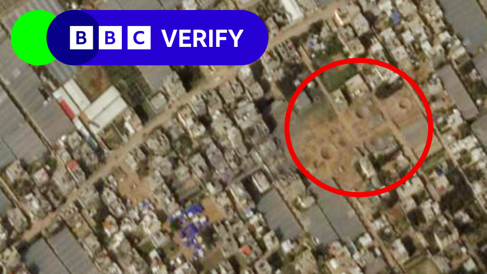
New satellite images reveal large craters in the city of Rafah in southern Gaza following Israeli strikes.
Some of the craters are only about 130m (426ft) away from rows of tents, where many people displaced by the war are sheltering.
On 12 February, after two hostages were rescued in an Israeli raid, Rafah came under intense aerial bombardment.
Your device may not support this visualisation
In the latest satellite images, taken on 14 February, several craters can be seen near the site of the operation.
BBC Verify has analysed a video provided by the Israel Defense Forces (IDF) of the rescue and located the operation to a district of Rafah where there are many plastic greenhouses.
Several of the greenhouses, as well as other nearby buildings, have been destroyed.
The latest satellite images also show how close the strikes were to areas filled with temporary structures housing people who have been forced from their homes.
Israel has repeatedly told Palestinians living in north and central Gaza to move south for their own safety - but fighting has now come to these very areas.
The IDF say it is targeting Hamas fighters who operate there.
Existing tent cities grow and new ones emerge
Rafah's population is thought to have increased five-fold in the months following the 7 October Hamas attacks, with 1.5 million people now estimated to be living there.
Vast spaces there have been filled with tents, including a main road.
From above, you can see that a main highway through Rafah has been clogged with temporary structures and blocked off to traffic.
Your device may not support this visualisation
BBC Verify has also been tracking some other areas where temporary camps have been set up, including the nearby Al-Mawasi area, where tent numbers have grown considerably over the last few weeks.
Your device may not support this visualisation
Al-Mawasi is a narrow strip of land by the Mediterranean Sea near the coast in southern Gaza. Israeli officials instructed people to take shelter in the area in the first two months of the war in Gaza.
Before the conflict it largely consisted of sandy dunes and agricultural land, but now temporary structures have increasingly been built along the coast.
A large area in the east - once completely empty - is also now filled with tents.
Your device may not support this visualisation
Graphics by Tural Ahmedzade.


 English (US) ·